Getting around Snohomish with Community Transit

Community Transit is here to get you where you want to go. We are proud to be a part of the Snohomish community — we live here, ride here, and drive here. Wherever you need to go in Snohomish, feel good about how you get there.
About Snohomish
Snohomish is located on the Snohomish River, southeast of Everett and northwest of Monroe. Snohomish lies at the intersection of U.S. Route 2 and State Route 9.As of the 2020 U.S. census, there were 10,126 people, and 4,221 households in the city.
Key destinations in Snohomish include its historic business and residential center in its downtown district, Harvey Airfield, the Snohomish Aquatic Center, its local Boys and Girls Club and senior center, Snohomish's public , and its many parks and nature preserves. These include Ferguson Park and Hill Park on Blackmans Lake; Morgantown Park and Pilchuck Park on the Pilchuck River; and Cady Park and KlaHaYa Park in downtown on the Snohomish River.
Community Transit provides bus, DART Paratransit, and Vanpool service to Snohomish from surrounding cities. Two of these routes travel from Everett Station (with limited service to the Boeing Everett Factory) to Snohomish and continue east along US 2 to Monroe, Sultan, and Gold Bar. Another route travels from Lynnwood and Mill Creek to Snohomish and follows the State Route 9 corridor north to Lake Stevens. Community Transit also operates a commuter bus route that connects Snohomish and Monroe to Downtown Seattle with intermediate stops on Interstate 405 and State Route 520. The city also has one park and ride lot, located near Avenue D and State Route 9, that is owned by the Washington State Department of Transportation (WSDOT).
Snohomish is also the southern terminus of the Centennial Trail, an intercity multi-use path for pedestrians, cyclists, and equestrians.
Popular Destinations
New Swift onboard digital signs signal your destination is near
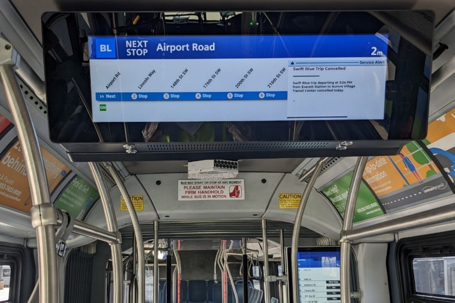 Community Transit asked riders and the community what would make their trip easy and comfortable and then tested onboard signs earlier this summer. Your feedback made the choice easy.
The new onboard signs will display:
- Swift line name and destination
- Upcoming stops and departure times
- Information on transferring to other transit services
- Key rider alerts
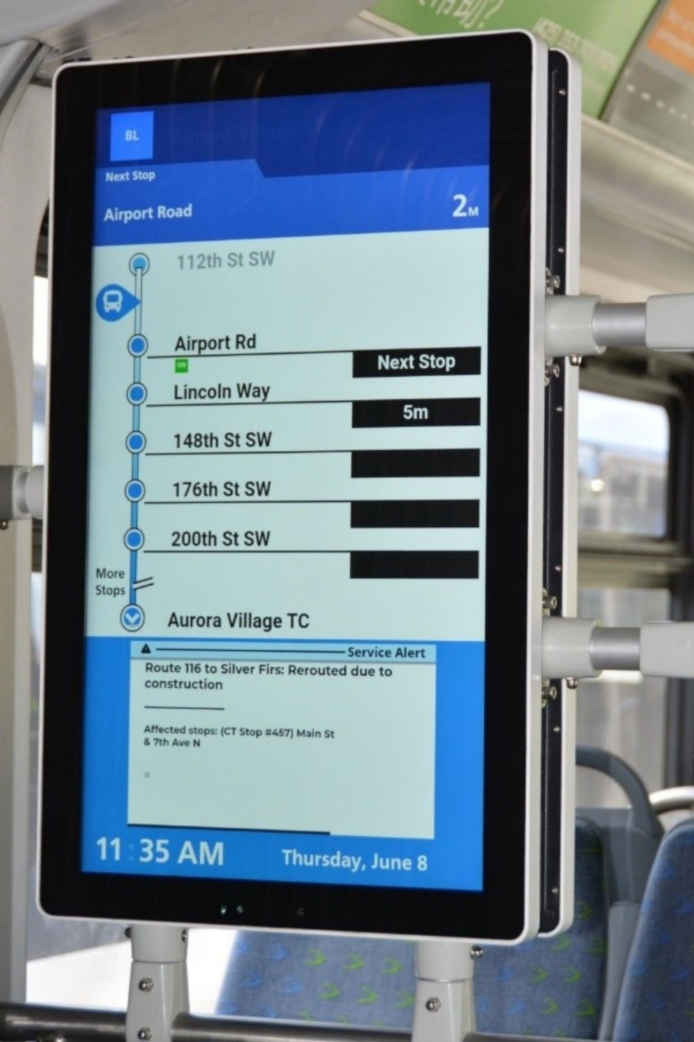
“These signs are designed to help our customers make quick, efficient decisions and feel confident as they ride our services. We value our customers’ time and want to help them optimize it on their trips with us,” said Christopher Silveira, manager of the Swift BRT program.
These new signs will be installed on all Swift buses on a rolling basis next year before the Lynnwood Link light rail extension opens in 2024. The new signs will not impact verbal announcements; you will continue to hear announcements over the loud speaker.
Swift provides fast, frequent service on busy corridors throughout Snohomish County, delivering you to your destination in minutes. A third Swift line, the Swift Orange Line, will open next spring. Learn more about Swift and how it can support your next trip.
